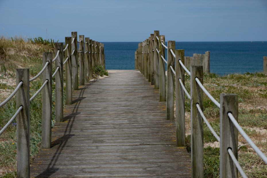
Morning view, leaving Baiona to catch a train to Porto.
I’ve been home for more than a month and I am enjoying the memories by posting these pages and reviewing my photos. My chosen path from Matoshinos, Portugal to Baiona, Spain was calculated as 138 kms (from town to town). The tally of kilometers I walked for the week was 187.7 kms and 255,953 steps.
What I loved:
The scenery – it was outstanding
Meeting people on the path
Exploring the towns, buildings, parks
The sense of accomplishment
Not carrying a backpack – it saved my back
The time was my own
What would I do differently:
Now that I have experienced a camino, I would book my own accommodation – a mix of hotels, guest houses and albergues (hostels) with private rooms. There would have been more opportunity to meet people, make connections and share meals Travelling alone was most difficult at dinner time, but once I was at a restaurant, it was fine.
I would take more time to stop and enjoy the surroundings during the day. I tended to walk the path the same way I walk at home – with the destination in mind. Although I slowed my walking and stopped to take many photos, I could have walked along the beach more or just chilled beside the path.
I would take more notes! I say this every time I travel.
I would love to do another walking holiday while I am still healthy enough to do so. Perhaps another Camino path, or a walking holiday in a different country. I will be on the look-out for another adventure in the not-too-distant future.
Thanks for reading. I will have another post about my time spent in and around Porto.
Our final day of the tour started with breakfast and a quick meeting with Joe. We were given options on how to spend the morning before heading back to Salt Lake City. Option 1 – Head back to the park to do the 1.5 hour Riverside Walk. Option 2 Explore the hills around Springdale with Joe in the Van. Option 3 – Chill at the hotel until check-out time of 11 am. Craig and I chose the Riverside Walk along with Barb, Gus and Enid. Jan opted for the tour with Joe and the others chose to relax at the hotel.
Zion National Park – Riverside Walk
Joe drove us back to the park and we agreed to meet him at the Zion Canyon Village at 10:45 am.
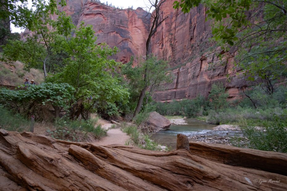
We caught the shuttle at the Visitors Centre and headed up to Stop #9 Temple of Sinawava (we had visited the day before). The next 1.5 hours was spent following the path along the Virgin River to the area called The Narrows with 3,000 ft canyon walls all along the way. It was a pleasant walk at tolerable temperatures at 8 am when we started.
We reached the start of the Narrows where the Virgin River travels through a 15km slot canyon. The river was running quite low and many, many hikers were embarking on the trek in the river. You can rent shoes and hiking poles at the Visitor Centre as the rocks at the bottom of the river can be quite slippery. Hikers are warned that flash floods can occur through the Narrows. Although we paddled in the river water, we were not undertaking a hike through the canyon most due to a lack of time.
Many red and yellow rental shoes and walking sticks
The walk back to the shuttle was lovely. We walked along the path and saw hanging gardens and along the river for different views.
Talk about living walls!
Hanging Gardens
At the shuttle stop #9
We caught the shuttle for a last view of the park as we headed to the Visitor Centre stop. From there it was a quick 10 minute walk to the Canyon Village (outside of the park) to meet Joe for the ride back to the hotel. He mentioned that he had just received a flash flood warning for Zion. Yikes! I don’t think it materialized though.
Once we were back, we quickly packed up and boarded the van for the 6-hour, relatively uneventful drive back to Salt Lake City. I was a bit sad that this adventure was over.
Thoughts about our tour
South West Adventure Tours was amazing and our guide Joe provided lots of customization and options for all the guests on the tour. Accommodation was excellent and all provided meals were very good. I highly recommend this company…and Joe! Would love to do a tour of Yosemite in the future.
If an opportunity arises I would definitely love to spend more time in Arches, Canyonlands and Bryce (my personal favourite). I’ve also discovered many other spots that would be amazing to visit in Utah. As always, there is so much to see and returning from a trip feeling like you would love to go back is a good thing!
Love, love, love small group tours. Don’t think I could ever do a big bus tour (like some we saw on our trip). I love the flexibility, personalization and opportunity to get to know our fellow travelers.
Thanks for reading my posts. Would love to hear your comments.
Stay tuned for a post on our visit to Northern Nevada for my grandniece’s graduation and our time spent in Salt Lake City.
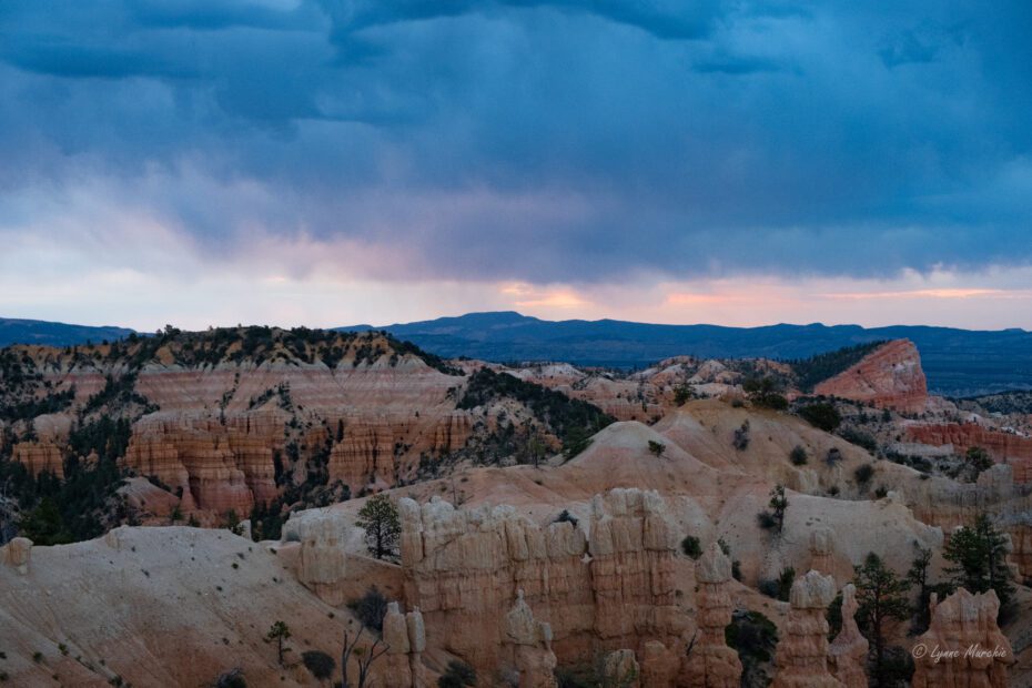
After our fun evening of country entertainment a few of us hardy-types joined Joe at 5:45am for a 10 minute drive in search of a Bryce Canyon sunrise. I thought we would be heading to Sunrise Point (it seemed to be a natural); however, Joe said that Fairyland Point was a better view for sunrise. It was a quiet spot – maybe only 1 or 2 others there. We positioned ourselves on the Fairyland Point trailhead and waited for the sun to come over the horizon.
Unfortunately, Mother Nature had a different plan. It was quite a cloudy morning in the east although it was clear to the west. The views were still amazing and it was great to have a quiet experience overlooking the hoodoos.
Fairland View Point
Early morning Hoodoo views
Virga showers in the distance – rain does not hit the ground
This was about all we saw of the sun above the horizon!
The Sunrise Gang
Back to the hotel for a hearty breakfast. The hotel was beautiful but we didn’t spend much time there. With a “coffee to go” we were back in the van heading towards Zion National Park the last of the Mighty Five National Parks on our tour.
Zion National Park
Entering the park from the 25 mile Zion-Mount Camel Highway is stunning. There is a 1.1 mile long tunnel built in the 1920’s which is limited in size (height and width). Large vehicles (including delivery trucks) need to be escorted through the tunnel at times when it can be restricted to one-way traffic. Fortunately, we were not there during one of the times so no delays for us.
View from a pull-out on Zion-Mount Carmel Hwy
Inside the park, vehicles are not allowed beyond the Visitor Centre, except for those staying at Zion Lodge. They run a shuttle service up and down the park to access at various stops for hiking or sightseeing. We were early enough in our arrival to have a good parking spot for the van at the Visitors Centre. We hopped on the shuttle as a group, going to Zion Lodge as a jumping off point for exploring the park. We agreed to meet back at the Lodge for lunch. Craig and I headed of to the Lower Emerald Pools, an easy 45 minute in and out hike through Juniper-Pinion forests up to the lower Emerald Pools. Temperatures were rising fast so by the time we reached the pool where the falls trickled over the pathway. It was a welcome cooling off. I imagine the falls are stronger in the spring, but the misty-ness felt great as we walked under the overhang. We decided not to proceed to the Middle Emerald Pool trail, but headed back to the Lodge instead to meet the group for lunch.
Walking under the mist
Falls were just a trickle
Lower Emerald Pool
This was a great place to stand on a hot day
Trail back to the Lodge
Red Arch Mountain
We enjoyed lunch with most of the group back at the Lodge. Because the temperatures were continuing to rise (expected to be over 100 deg), we decided on a short walk to the next “up canyon” shuttle following the Grotto Trail with Barb, Gus and Madelon. On the way, we discovered a mule deer resting in the shade of a hollow in the hill. We weren’t the only ones feeling the heat!
The Grotto is shuttle stop #6 of 9 stops. We then travelled to stop #9 – Temple of Sinawava. This is one of the most popular stops in the park where people access the River Walk to the Narrows slot canyon. Not sure of the amount of time it would take, we elected to cool off by the river for a little while.
Back on the shuttle to go “down canyon” stopping at #8 – Big Bend. This is where the Virgin River follows a big curve in the canyon. We didn’t go down to the river; however we did see some Condors flying high above the canyon near the formation called The Organ. Apparently there is are four condors living in this area. We were told we might see hikers on the Angel’s landing trail high above us. I was sure that I saw a couple of people…but they are not visible in my photos! Angel’s Landing requires a special permit to hike. It is a narrow trail with the last half-mile being one-way, using chains along the 3 ft wide path. Definitely not for me – ever!
View of the Organ from Big Bend Stop #8
I believe this is part of the Angels Landing Trail
Angels Landing – This is not my photo!
Back on the shuttle back to Zion Lodge. The heat of the day had made us pretty thirsty and the five of us decided it was time for an afternoon beer. We saw Scott, Mick and Aiden in the lobby. They were pretty much ready to go to the hotel. We agreed to meet everyone at the Visitor Centre after we finished our drinks. Jan and Enid had also come looking for us. We headed down on a busy shuttle to the Visitor Centre and with everyone on the van, Joe drove us to the Hotel – Springhill Suites Zion. Beautiful property with stunning views.
Craig and I chose to walk to the local grocery store for something light for dinner. Springhill is a nice community, with a free shuttle through town that will also take you to Zion. Quiet night in preparation for our final day of the tour.
View from our hotel in Springdale
Next up – Day 6 Zion NP and trip back to Salt Lake City
As mentioned in the last blog, the Pioneer restaurant at Capitol Reef Resort could not accommodate us for breakfast due to a large tour group staying at the property. Joe had scouted out another location in the town of Torrey just a couple of miles down the road. Alas…nothing was open at 7 am in Torrey! So off we went – a little caffeine deprived – entering the Scenic Hwy 12.
Boulder Mountain Lookout
The landscape changed soon after we left the Torrey area and started gaining elevation. We entered the Dixie National Forest, the highest timbered plateau in North America. With a stop at at about 9600 ft, we enjoyed a morning overview to the east, with the Henry Mountains in the distance.
As we traveled towards the small town of Boulder, we entered into cattle ranching territory…and around one corner we came face-to-face with a large herd of cows and several cowboys on the road. That certainly work everyone up! We were guessing that they were taking the cattle to their summer pastures.
Singing Canyon
Just after the town, Joe turned left onto a secondary road promising us an exciting stop ahead. About 20 minutes later, he parked in a pull-out and we exited the van. The trail led to a slot canyon, called the Singing Canyon where the acoustics were amazing. Louise took centre stage and sang “America the Beautiful”, then Madelon sang a couple of verses of “He’s got the whole world in his hands”. In the meantime, Joe was recording on his phone. It was a great experience, and there was only one other person there (he was leaving as we arrived). Truly a hidden gem.
Entrance from the roadLooking up – 80 ftTaking it all inMadelonJoe captures the experienceDoing what young men do…Celebrating Back to the vanCottonwod and canyon wallRock formations were so interesting
Continuing along Scenic Hwy 12, the next point of interest was the “Hogback” – a section of the highway with steep drop-offs on both sides. From a pull-out, we had some great views of both vistas. As we have learned on the trip, cottonwoods only grow where there is water, so we knew there was a river or stream along the green ribbon in the photo on the left.
At this point, we still hadn’t found a place for breakfast (and most importantly coffee – if you know Craig and me). Joe had another hidden gem up his sleeve. A little further along Hwy 12 tucked in on the side of a hill was Kiva Coffee House. Such a great find. Tasty coffee and pastries with friendly service . This area is just at the start of the Escalante Canyons where the landscape features some of the “staircases” .
Kiva Coffee House and Cottages
Escalante
Back on the road towards the town of Escalante. First stop was the Escalante Interagency Visitor Centre housed in a Gold Leeds certified building! We viewed a 20 minute film about the geological history of the Grand Staircase-Escalante National Monument. It seems to be a very interesting area worth exploring on another trip. However; we were focused on our next destination – Bryce Canyon.
We had lunch at a great restaurant – Escalante Outfitters. It was a busy place and lunch took a while, but food was delish. Looks like a great place to stay or to stock up on gear for outdoor adventures.
With everyone full from lunch, we continued on beautiful Hwy 12 towards Bryce Canyon. Just before the entry gates to the park, we stopped at the Mossy Cave and Falls. We were lucky to grab a parking space as someone was just leaving. The falls are man-made, resulting from a “tropical ditch” built by Morman pioneers to divert snow melt and monsoons providing water to the nearby towns of Tropic and Canonville.
The easy trail from the parking lot led to a bridge that crossed the stream, then uphill for a nice view of the waterfall. A short trail took us to the Mossy Cave. It was pretty unimpressive, but I’m sure it is beautiful when the icicles hang from the inside during the winter.
Back down the hill and across the bridge, I climbed down to the stream and walked to the waterfalls. Its a great place to cool off and soak one’s hot feet! Craig had opted for that rather than going to the Mossy Cave.
Our fearless leader The spray from the falls were refreshing
Bryce Canyon National Park
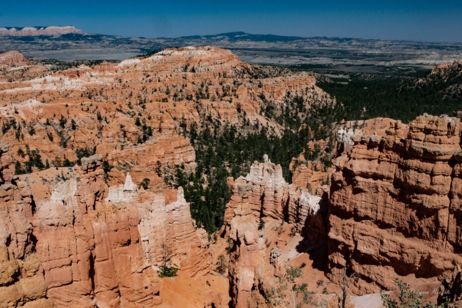
Now on to Bryce Canyon! The group was given some options for our time here: hiking the Navajo Loop from Sunset Point, or going to Inspiration Point and walking back to Sunset Point or driving back with Joe. Eight of us chose to hike the Navajo Trail with an expected completion time of about 1.5 hours.
This is an amazing hike, walking amongst the ancient hoodoos. The switch-back trail descended deep into the canyon. As I watched the people coming up the trail, I thought to myself “I will probably be taking this very slow on the way back, so I will take more pictures on the ascent”. I failed to recognize that this was a loop and we would return on a different trail. I would have taken more photoson the Two Bridges Trail had I known.
The descent is about 500 ft, coming out to a different landscape of pine trees at the bottom. Now it was time to make the climb. Not going to lie…it took a lot of effort and many rests for me to stop and enjoy the view. Craig continued on at a steady pace. Back at Sunset Point, Joe was waiting for us. Craig was the first back at 1 hour 2 minutes…I was a couple minutes behind. We were surprised at our timing and felt a great sense of accomplishment.
View of Switchbacks on Navajo Loop
Views to the horizon
Thor’s Hammer (on the left)
Heading down the canyon amongst the hoodoos
Two Bridges Trail
Canyon Floor – Douglas Firs
Mick and Aiden
Every where you looked – beauty
Wall Street Trail
700 yr old Douglas Fir nestled amongst the hoodoos
Beautiful Slot Canyon path
We headed back to BW Plu Bryce Canyon Grand Hotel to check in and get cleaned up for a Western dinner show at Ebenezers Barn and Grill (this is correct…Barn not Bar). Not being big country/western fans, craig and I were a little skeptical. The evening started out with a buffet dinner. We chose Flat Iron steak which came with coleslaw, potatoes, baked beans and a dessert. Everything was prepared perfectly which surprised us. The entertainment started after dinner and featured a series of hits which have shaped country music. It included songs that reminded me of my Dad from artists like Hank Williams, Marty Robbins, Patsy Cline and Willie Nelson. The performers were great (and a couple of them just in their teens). Nice ending for an awesome day.
Entertainers on the left were 16 yrs old
Checking in on basketball scores!
Up Next: Day 5 – Bryce Canyon Sunrise and Zion Park
After another hearty breakfast at Homewood Suites, we were in the van again just after 7 am, heading out Hwy 70 towards Hwy 24. There will be two stops on our tour today. Goblin Valley State Park and Capitol Reef National Park.
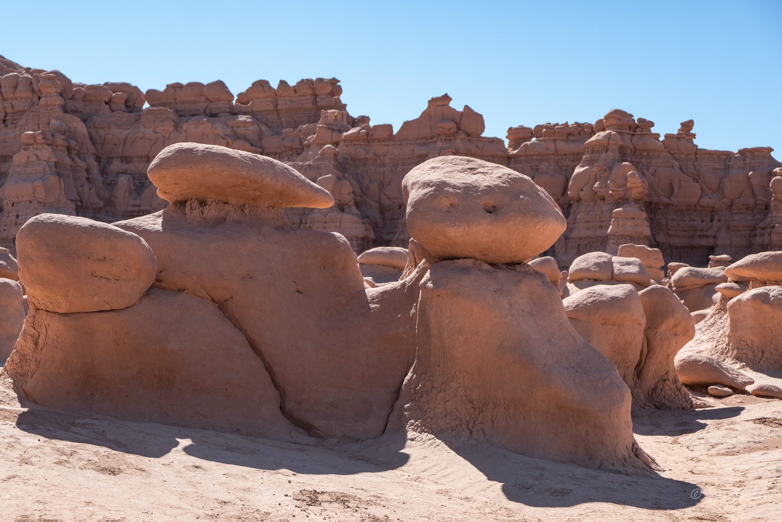
Goblin Valley State Park
I didn’t know much about this park before our arrival. Geologically speaking, the goblins in the park were formed by the gradual erosion of Entrada sandstone (from about 170 million years ago) when the area was a tidal flat next to an ancient sea. With the tides, the sand washed-in, eroding the hoodoos and depositing silt and clay. Weathering wore down the different layers, smoothing out sharp corners. Aided by decomposition and erosion the rounded caps and curves of the “goblins” were formed.
When you first see this area, it feels like you have landed on Mars! There are no defined trails here – people can wander around the 3 square miles of the main attraction filled with thousands of hoodoos.
Joe challenged us to come up with a name for the area, or for specific hoodoos. We spent the next 45 minutes inspiring our imaginations. As we gathered for a group shot, Joe announced that Barb won the challenge with her name of “Smurfville”. Not sure what the prize was. 🙂
Three Sisters guarding the park
Like Mars or Smurfville!
The tall hoodoos will eventually be like the smaller ones
Toadstool Alley
Could be gnome homes…
Pouting turtle
What do you see?
Bird on a doggie
Let me get the right framing…
Gathering of the Goblins
Our travel group
Capitol Reef National Park
We continued on Hwy 24 to Capitol Reef National Park. This is the least visited of the Mighty 5 but has an interesting geology. It’s a 100 mile long warp in the earth’s crust, known as the Waterpocket fold. This describes the “reef” part of the name. Like a giant barrier in the ocean (think Great Barrier Reef). The Capitol part of the name describes the dome-like formations, similar to state capitol buildings.
On arrival, we drove through the historic district of Fuita past the schoolhouse and the fruit orchards. Visitors are allowed to pick fruit from the trees in season. Gifford House sells famous fruit pies (although we didn’t taste them). We had a quick visit of the Visitor’s Centre then proceeded to a beautiful, shady picnic area where we lunched on excellent sandwiches/wraps provided by Sweet Cravings (where we had lunch the previous day). We were surrounded by beautiful old cottonwood trees, and a few mule deer who were probably wishing for a handout.
Old Cottonwood
After lunch, Joe drove us to the trailhead for the Grand Wash Trail for this day’s hike. This is a famous gorge that cuts through the upper portion of the waterpocket fold of the park. The steep canyon walls, made me feel pretty small. It was a hot day, with heat radiating off the walls but once we reached the narrows it was quite shady. Then it was back to blazing sun for the last 15 minutes as we approached the parking lot where Joe was picking us up.
TrailheadCraig and Jan finding shadeNarrows
On the way out of the park, we had a final stop at Gooseneck Overlook and Sunset point. Aiden stepped across the “abyss” at Gooseneck. The short walk up the Sunset point trail provided some great panorama views.
Gooseneck Point Overlook
Aiden stepping over the abyss
Sunset Point Trail
Sunset Point
It was a short drive to our next accommodation at Capitol Reef Resort in Torrey. Although it is an interesting property (you can stay in a teepee or Conestoga wagon), the rooms were quite dated, and the air-conditioning didn’t work for some rooms. The views were beautiful though.
Because there was a large tour group at the resort, the restaurant on the property could not accommodate us for dinner. Turned out they couldn’t provide a timely breakfast for us in the morning either. Wouldn’t recommend this property. Definitely would recommend the Rim Rock Restaurant across the street for dinner.
View from Rim Rock Restaurant
Teepee Accommodation
Morning Light – Torrey
Evening Glow – view from hotel
Sunsetting
Up Next: Day 4 – Boulder Mountain Pass, Singing Canyon, Escalante, Bryce Canyon.
After such an amazing first day of the tour, it was hard to imagine that the scenery and experiences would just keep getting better! At 6:30 am we were eating breakfast at the hotel so we would be in the van ready to tour Arches National Park at 7:00 am.
Arches National Park
Access to this park has been limited in the summer of 2022. Visitors must have a timed reservation for the park to gain access. As we were part of a tour this didn’t apply to us, but it was great to have smaller crowds at some of the most popular spots.
Four of our group had chosen to hike up to Delicate Arch – a 2+ hour return hike much of it on sheetrock and without shade with over 480 Ft of elevation. I learned that the last part of the hike, even before you could see the arch, was a narrow ledge with a very steep drop-off. I am not great with heights without some kind of guard rail. I decided not to go as I was afraid that I would get up to this section and not complete the hike to the Arch. We dropped off Mick, Scott, Aiden and Gus at the trailhead and wished them luck!
Joe drove the rest of us to a viewpoint where we could see Delicate Arch (about a mile away) and take some photos. There were quite a few people enjoying the up close views.
For the less adventurous, Joe dropped us off at the Park Avenue Trail for a 45 minute hike ending at the Courthouse Towers Viewpoint. We descended a flight of fairly steep stairs to the canyon floor. It is said that the walls of the canyon reminded early visitors of the tall buildings of large cities (like New York), hence the name. There are many interesting formations along this trail which are part of the Courthouse Towers. Parts of the trail featured wavy formations which remind us that Utah was once underwater. We met a park ranger along the path. She was a former teacher who decided she wanted to work outdoors. Good for her! A most enjoyable hike and a great alternative to the hike to Delicate Arch (in my opinion). Poor Joe, our tour guide, has not completed this hike as he always needs to drive the van to the other end of the trail to pick up the hikers. I would have been happy to walk out and back!
Trail Head – Park AvenueSeries of steps leading to the trailCity BuildingsQueen Nefertiti formationThe Organ in the distanceYou can see the impact of the receding seasThe Three GossipsAnother view of The Organ (700 Ft)Sheep Rock (400 ft. tall)Louise, Madelon and BarbNear the end of the trail
We drove back to the Delicate Arch trailhead to welcome the boys back from their hike. They all said it was amazing and they were glad they did it…but two of them said the narrow part of the trail was very scary.
Next stop was Balanced Rock. This formation is 128 ft (39 m) tall. It’s a geological formation where the “rock” is attached to an eroding pedestal giving the illusion of balancing. Eventually the 3600 ton rock will fall due to erosion, but it may take several hundred years to happen. Joe is selling tickets for this future phenomenon…in case anyone is interested.
Start of the trailCraig having a closer lookCan you see the face of an old man?Dinosaur-like
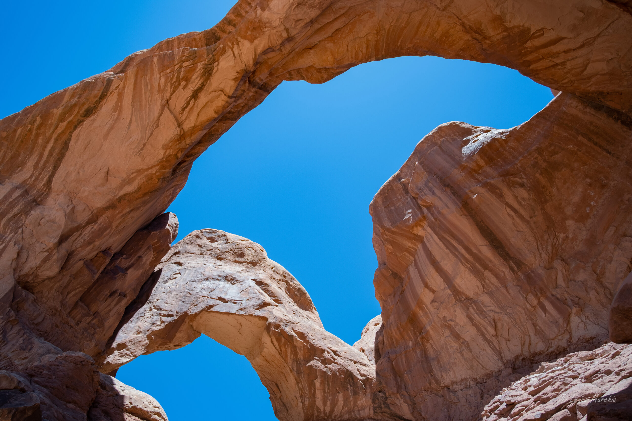
A short distance down the road we visited the Windows Section of the park. There are four arch formations in this area. Craig and I decided to walk to the furthest one first – Double Arch. Double Arch is an impressive feature—the tallest (112 ft/34 m) and second-longest (144 ft/44 m) arch in the park. You can certainly see it from the parking loop, but it is much more impressive up close.
We had time before meeting back at the van, so we did a quick loop of the three remaining arches North and South Window and Turret Arch. It is amazing to see these 4 arches within 2 square miles. Lots of steps and sometimes uneven paths…and beautiful views. Made it back to the van within a few minutes of the deadline, although I managed to take a hard fall off the sidewalk, bouncing off a wooden fence. No major harm.
Parade of Elephants
Looking up at Double Arch
Double Arch
Turret Arch
Turret ARch
Finding Shade
NORTH ARCH
SOUTH ARCH
Lunch and a fortunate discovery
After a full morning of hiking and arch viewing, we returned to Moab for lunch at Sweet Cravings Baker6 & Bistro. Delish sandwiches and wraps, complete with a small side salad and a “crave of the day” treat. While at the restaurant, I was able to retrieve a voice mail. Turns out it was AAA (American Auto Association). My wallet had been found and turned into a Ranger at the Island in the Sky. They had tracked me down through my BCAA card in my wallet. How do you spell r-e-l-i-e-f? I was elated. I asked Joe if it was possible to go to the Visitors Centre at Canyonlands and he generously offered to drive me there. The rest of the group was happy to hear of my good fortune. They went back to the hotel for a little rest, swim, shopping etc. Craig, Joe and I headed back to Canyonlands – about and hour and twenty minutes return. The Ranger at the park entrance was aware of my found wallet and I sprinted into the Visitor Centre to retrieve it and offer my undying gratitude. Everything was in the wallet including about $250 cash. This renewed my faith in people doing the right thing! Definitely made for a most enjoyable rest-of-the vacation.
Petroglyphs
Back to the hotel to pick up the rest of the group to head just outside of Moab, along the Colorado River to see some petroglyphs on a canyon wall on Highway 279. The ancient art is from two cultural periods (Archaic 6,000 – 1,000 BC and Fremont 450 – 1300 AD). They are quite high on the sandstone walls which is a testament to the amount of erosion over the centuries. Thankfully, they are not in close reach to those viewing them, which helps to preserve them. Some of the art looks like aliens! Bonus was the view of the Colorado river directly across from this site.
Some looked like aliens
Like a line of dancers
There are sometimes climbers on these sandstone cliffs
Colorado River
Back to Moab. Everyone was on their own for dinner. Craig and I had a bit of a wander along the main street and we settled on gelato from the Food Truck Park for dinner after a recommendation from Joe who was just exiting with his treat. The back to the hotel to get rested for another early morning.
Next Up – Day 3 Goblin State Park, Capital Reef National Park
When we were invited to my grandniece Callie’s high school graduation in Spring Creek, Nevada, it was a perfect opportunity to investigate visiting some of the National Parks of Utah…definitely a bucket list item. After some research, I chose South West Adventure Tours. The small group format, opportunity to do some hiking and a one-week duration fit the bill. The tour started an ended in Salt Lake City, which was our flight destination.
We arrived in SLC late Sunday afternoon and checked into our hotel (Courtyard by Marriott) and found a great restaurant for a light dinner (Settebello Pizzaria) for some authentic Napoletana pizza…YUM!
We were ready to go at 7 am Monday morning and found our guide, Joe in the lobby along with our 9 travel mates for the next week – Barb and Gus (Ohio), Madelon (Ohio), Louise (Ohio), Janice (Pennsylvania), Scott, Mick and Aiden Warner (Grandfather, Father and Son from Ohio), Enid (New Jersey). And off we went!
Day 1 – University of Utah – Price, Canyonlands, Moab
Driving down Hwy 15, Joe explained that we would stop at the Utah State University Eastern Prehistoric Museum in Price, Utah to get an appreciation of the lands and life that were 3 billions years in the making. We would be visiting and walking on these lands over the next week.
While in Price, Joe took us to Tangerine Eatery to order lunch for a picnic in Canyonlands National Park. Great little restaurant…the breakfasts looked amazing. Lunches resided on the back seat of the van, next to Aiden. There was some concern about having a teenager looking after them but they were well guarded!
Canyonlands National Park – Island in the Sky
Our visit to Canyonlands focused on the Island in the Sky . This section is flanked by the Green River to the west and the Colorado River to the east. It creates a mesa that appears to be an “island”, boasting views of horizons over 100 miles away.
We stopped at the White Rim Overlook to have our picnic lunch. It took a few passes to find a group leaving their picnic table. Once we parked and started setting up for lunch, we realized how windy it was! Everyone had one hand on their box lunch as they ate with the other! The sand was blowing everywhere.
After lunch we had some time to explore. Craig and I started on one trail with the others, but decided to walk the Gooseberry Trail that Joe recommended (about 30 – 40 minutes out and back). The varying terrain, interesting rock formations and views of Gooseberry and Monument Canyons are stunning, even with the gusty winds. We didn’t realize that none of the others had decided to take this trail. They were sheltered from the wind and sand in the van and Joe set out to find us. We were almost back when we met him. Oops!
On the Gooseberry TrailA little hazy on the horizon – result of the winds.Good to have the “sticks” during the wind.So many interesting rock formationsOh the view!Definitely windy in this shotSel Mountains in the background. This is a good view of the White RimYou can see the Colorado River in this shot
Next stop was at the end of the Island in the Sky Road at the Grand View Point Overlook. We could see the definition of the White Rim which is a sandstone bench about 1200 ft below. Also visible is a section of White Rim Road which is about 100 miles long used by 4-wheelers to explore the area.
White Rim and the meandering road
No, we will not take a step back!
What a photographer does to get a great shot!
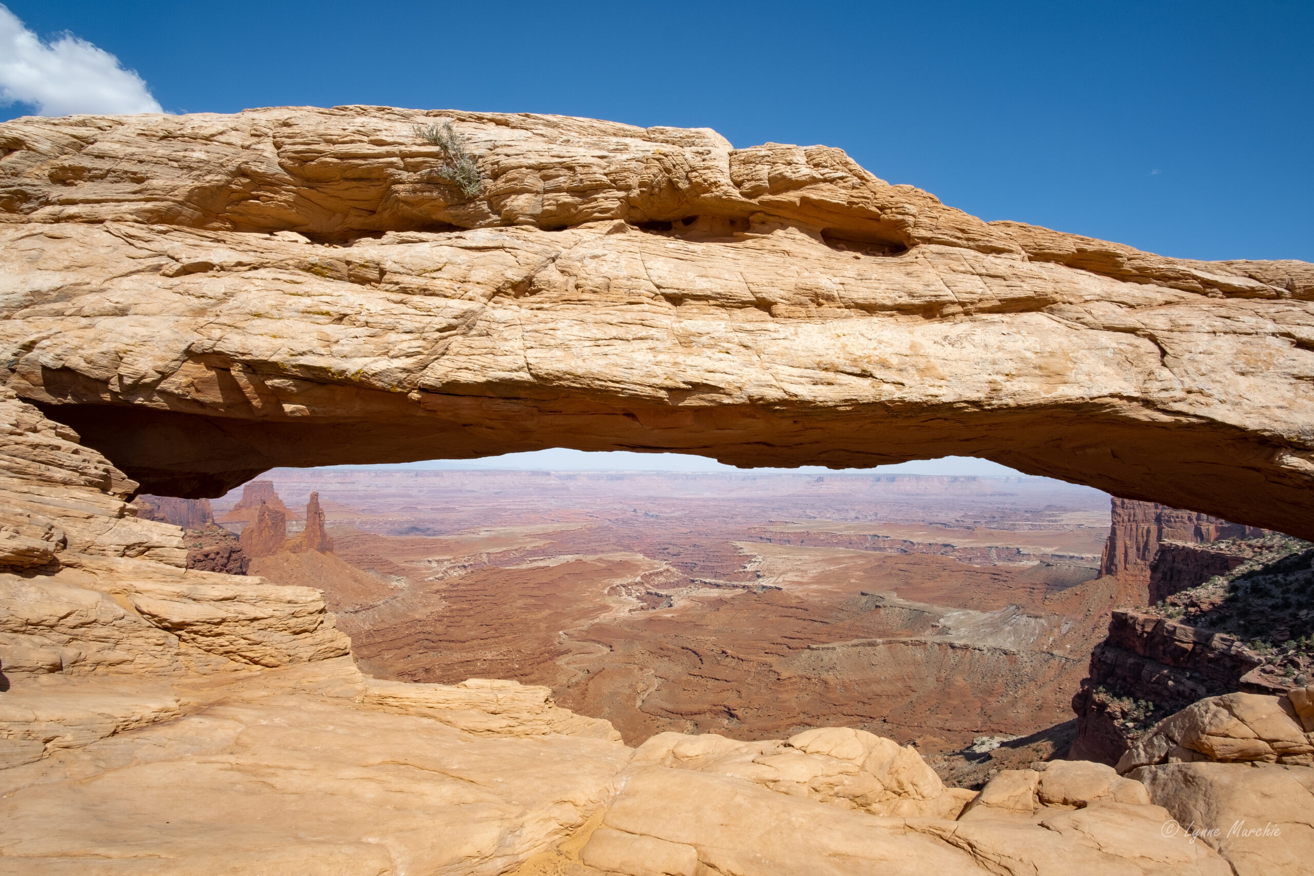
Final stop was at Mesa Arch, a famous photography spot at sunrise. An easy 15 minute walk brought us to this popular site and even in the afternoon, the views were amazing. Not too many people around late in the afternoon so we were able to get some good shots. Shout out to Gus (a fellow photographer in our group) for using my camera to take pictures of Craig and me.
Multiple views of Mesa Arch
We didn’t have time to have a look at Dead Horse State Park to see where the final scene of Thelma and Louise were filmed. It is located just outside the park boundaries. Next time…
Moab and an unfortunate discovery
Onward to Moab where we would spend the next two nights. Time for a shower before heading out for a group dinner. It was a this time that I noticed my wallet was missing. I thought it must have fallen out of my backpack in the van – but it wasn’t there. What can you do? I resigned myself to cancelling credit cards right away and replacing my driver’s license and other ID when I got home. Fortunately we still had Craigs credit and debit cards to use.
Dinner was good, but service was extremely slow. I’m thinking that Joe will be finding a different venue for the next tour group. Back to the hotel for a quiet evening. The hotel was spacious and comfortable and close to everything. Homewood Suites Moab
If you’ve read my two previous blogs, you’ll know that Craig and I explored Northern Vancouver Island and sailed the Inside Passage on BC Ferries (Port Hardy to Prince Rupert). This blog,will cover our visits to Prince Rupert, Terrace, Nishga’a Nation (The Nass Valley), Smithers and Lillooet.
Prince Rupert
We disembarked the ferry at about midnight. It was a short drive to the hotel in downtown Prince Rupert and it felt good to sleep after our 16 hour sail from Port Hardy.
We were lucky with the weather. A beautiful sunny day to walk to a few sites near downtown. First stop…a Starbucks located in the local Safeway! Then we wandered to Mariner’s Park which overlooks the harbour. There’s many tributes to sailors including the flags of Denmark, Iceland, Norway and Sweden recognizing the Scandinavian influence in the area. I loved the whale’s tail that Craig sat on while he enjoyed his coffee.
Mariner’s Park overlooking Prince Rupert Harbour
Along the harbour and next to the marina is a fun community called Cow Bay. You can read about the history of Cow Bay in one of the pictures below. The area is full of shops, restaurants, coffee shops and a great looking B&B. We had fun wandering through the shops and the marine museum, had a seafood lunch then saw a group of people on water bikes in the harbour. That looked like fun. Next time…along with many other things that we didn’t see during our 3 hour walk in Prince Rupert.
Back in the car to continue the journey. The drive from Prince Rupert to Terrace is spectacular. We travelled beside the Skeena River, which looked like a large lake in some areas. And the mountains were stunning. It was a pleasant 2 hour drive (we stopped a few times for photos).
Scenery from Prince Rupert to Terrace
We stayed in an AirBNB in Terrace about 10 minutes from the downtown area. It was a lovely house…great kitchen and lots of room. It was our home for two nights. I like Terrace. It’s a young city with a blend new and older houses with big yards. A great place to raise a family…if you can survive the winters!
Craig’s sister-in-law, Louise, was in town visiting her family so she dropped by for a visit. We haven’t seen her for a couple of years.
We spent the next day exploring the Nass Valley, heart of the Nishga’a First Nations. The Nishga’a treaty was the first modern-day treaty in BC negotiated between the Nishga’a nation, Province of British Columbia and Government of Canada and it came into effect in May 2000. The Nisga’a Final Agreement is the first treaty in British Columbia to provide constitutional certainty in respect of an Aboriginal people’s Section 35 right to self-government. It recognizes Nisga’a Lands and opens the door for joint economic initiatives in the development of the Nisga’a Nation’s natural resources. It took over 100 years to come to this agreement.
We headed out of Terrace on Hwy 113 (representative of the 113 years it took to finalize the treaty). Again, a spectacular drive. The mountains around Terrace are impressive. Our goal was to get to the Visitors Centre to understand all the sites to see. We’d heard about the Nisga’a Museum and the four Nisga’a villages along with the impressive lava beds.
The Visitors Centre is located next to the campground in Nisga’a Memorial Lava Bed Park. This is the first provincial park jointly managed by a First Nation and BC Parks. We learned here that most of the “attractions” were closed because of COVID protocols. Disappointing, but we discovered that we could do a self-driving tour to points of interest and the four first-nations villages located in the Nass Valley.
First stop was in Gitlaxt’aamiks (home of people of the ponds). We picked up the auto tour map at the general store. The totems located at community building represent the 4 Pdeek (tribes) of the Nisga’a Nation: Raven, Wolf, Killer Whale and Eagle. This village is considered the capital of the Nisga’a Nation and overlooks the flow of the lava beds that erupted in the 18th Century.
Throughout the park are opportunities to see the lava beds up close. There is a tour that takes you to the lava cone, but wasn’t available during our time there. However, we were able to see several areas of the lava beds. The eruption happened over 266 years ago – Canada’s last volcanic eruption.. 2000 Nisga’a people lost their lives. This park serves as a memorial and a reminder of the importance of respect for both the natural world and the wisdom of the elders.
The next village we visited was Gitwinksihlkw (place of lizards) on the north side of the Nass River. The vehicle bridge is flanked by four totem poles (Eagle, Wolf, Raven and Killer Whale). In the village we were able to access the 400′ suspension bridge which used to be only access to the village. From the bridge, we could see two fish wheels which we think has something to do with fish counting.
Our next stop would have been the hot springs, dwelling place of Sbi Naxnok (supernatural spirit). The sulfur smell of the hot springs is said to be the smell of the spirit. This is a designated heritage site. Unfortunately, like many other places, it was closed due to COVID Next time we are in this area, it will hopefully be open.
The village of Laxgalts’ap (village on village) was built on a series of Nsiga’a communities that occupied this site for milennia. The Nisga’a Museum is located near this village. It houses cultural treasurers from the 19th and 20th centuries. Again, we were unable to see inside due to COVID restrictions.
NIsga’a Museum
We followed Hwy 113 to the very end to visit the fourth village, Ginglox (place of skulls). In the past, invaders where met by Nisga’a defenders to protect their land and resources. Apparently they would display the skulls of the invaders on posts as a warning to others. Today, the village is famous for welcoming visitors from around the world to hike, kayak, boat and sport fish. We met a local man who was taking his child to the community centre. He talked about how the community was blessed with ample food from the sea, and fresh water from the mountains. It is a beautiful place.
Ginglox
Other stops of interest in the Nisga’a Memorial Lava Bed Park that we visited during our 5 hour visit included:
Vetter Falls – just a short walk from the highway. The stream disappears under the lava 5 km downstream and traps fish such as steelhead. Apparently because they are confined to this short stream, they have developed snake-like bodies with large head. Locals call them Phantom Fish. We didn’t see them in the pools, but the falls were beautiful
Vetter Falls
Drowned Forest – When water levels are high, the Tseax River flows over the land and through the forest. I imagine this is quite the sight during the rainier seasons. It had been pretty dry this summer.
Drowned Forest
Lava Lake – Thousands of years ago a glacier moved through the valley and created the depression that holds the lake During the lava eruption, molten lava flowed to the creek bed, damming the stream and raising the level of the water by 30 metres. Not sure about the story of the car below but there was a young family enjoying a picnic on the beach. Pretty sure this was their car.
It was a great day spent in a culturally- and scenic-rich area. Highly recommended!
We left Terrace the next day, but not before seeing a site that Craig’s sister-in-law had recommended.
Ferry Island is located along the Skeena River as you head south towards Smithers. There’s a large campground and walking trails around the island. But the big feature is The Spirits of the Forest carved into the cottonwood trees throughout the park. They are the work of artist Rick Goyette. I think we missed a few at the beginning of the walk. We asked another hiker about them, and she gave us some hints. Once you find one, the rest are a little easier to find. I took pictures of about 35 of them, and I’m sure there were more that we missed. I’ve posted some highlights below. Definitely a fun morning walk!
Now on to Smithers. Again, the views were amazing. We stopped for a quick barbequed lunch at a rest stop…that had wifi (that made Craig happy). Then we continued on to Smithers for our next overnight stop.
On the road to Smithers
By the time we got to Smithers, settled into the hotel and decided on where we would have dinner, we didn’t have too much time to explore. We had dinner at a locally-run family restaurant Steakhouse on Main. Craig and I shared a giant steak, and it was cooked beautifully. After dinner, we walked across the street to an ice-cream vendor then walked around the downtown area. Smithers adopted an Alpine theme in the ’70s and Alpine Al became the guardian of Main Street and official mascot of the town. It was quiet on the streets (as evidenced by the empty stage!).
Next day was a long drive to Prince George with a quick stop in Quesnel. Craig spent part of his early childhood here, so we had a quick photo at the water wheel next to the bridge.
Quesnel
Another quick stop in Vanderhoof for a picnic lunch at the Community Museum. The smoke from all the fires burning in BC was noticable.
We spent the night in an AirBNB in Prince George. It was a little cooler and rainier here, so other than a quick stop at Costco to gas up, we didn’t spend any additional time here.
The next day started out rainy, but gradually improved. We headed to Lillooet for our final overnight of this trip. When we turned off Hwy 97 to Hwy 99, we saw the local fire on the side of the mountain. Not close enough to be scary. We stayed at a lovely little AirBNB overlooking the river. Our host, Thyra, was fantastic. She picked fresh plums and grapes from the garden.
We decided to dine at the local winery, Fort Berens Estate Winery. We dined outside with a view of the fire on the mountain top and the firefighting helicopters coming home for the evening. Dinner was lovely, and the wine was good. A nice final evening of our fantastic “northern” trip
Our final stretch home was on Hwy 99 to Pemberton where we stopped at Mile One Eating House for a delicious and very filling late breakfast. Highly recommended if you are in Pemberton. We also picked up some famous Pemberton potatoes to bring home.
The final part of our journey was less than spectacular as we were delayed over an hour through Whistler due to road contruction, then being in the rush hour line-up through West and North Vancouver. It was good to arrive home!
We loved this trip. I feel there was so much more to see, so perhaps a repeat trip to some of these areas is in the cards for the future.
Continuing the story of our road trip in August 2021…
We had a reservation on BC Ferries to travel from Port Hardy to Prince Rupert. The ferry sailed at 7:30 am; however, because of onboarding procedures (checking ID, etc), passengers are required to be at the terminal 90 – 120 minutes ahead of sailing. So there we were at 5:45am waiting to board. Craig and I were struck by how friendly all the BC Ferries staff were at such an early hour!
Safely boarded, we checked into our stateroom. We decided this was a good investment to have a place to store our belongings including our electric cooler and to have a place to put our feet up during the 16 hour sailing. I was surprised to see it had a TV and a shower!
We travelled on the Northern Expedition. The ferry was clean, didn’t feel crowded, and had lots of comfortable seats. Some of them faced out to the port and starboard so you could watch the scenery go by. Also lots of room to wander the decks outside for bigger views. That’s were I spent most of the journey. People were not allowed to stay in their vehicles or even go to the car decks as it is all enclosed. However, about every 2 – 3 hours, there was an announcement allowing people 15 minutes to go to the car deck to retrieve items, or check on their dogs.
The beginning of the journey is across open water, and there were quite a few queasy people. After about an hour, we entered the Inside Passage where the waters were very calm.
I loved that there were announcements of places of interest as we passed. Lots of lighthouses many of which were built to guide sailors to the Klondike. There was an unsolved murder of a lighthouse keeper on Addenbrooke, and some mysterious disappearances on Egg Island.
Addenbrooke Lighthouse
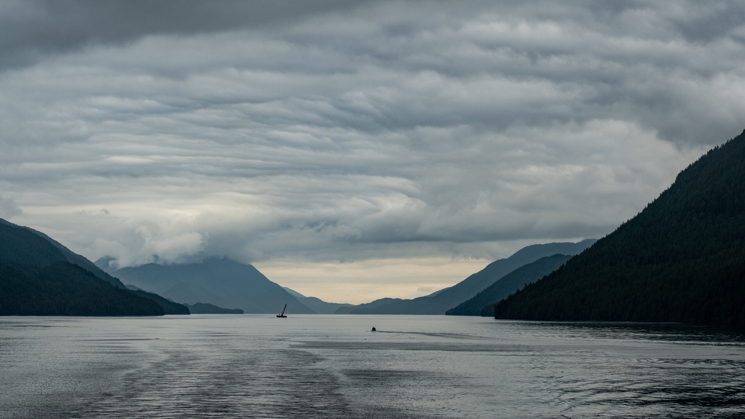
The inlets and fjords all along the journey were so picturesque. Although it was cloudy for most of the sailing, the views were still mesmerizing. And because the Inside Passage is so protected, it was quite pleasant to be outside on deck.
We had a stop at Klemtu which is an isolated community on Swindle Island where the main industry is aquaculture. A group of kayakers disembarked here. I was curious to know where they were going. This area is surrounded by the Great Bear Rainforest. I’m sure the kayakers would be seeing some amazing sites.
Further along, the sun came out for a while as we approached and passed by Bella Bella and Shearwater. Many years ago, Craig did a consulting gig at Shearwater!
Shearwater ResortBella BellaBella Bella
I can help but post more pictures of amazing scenery along all of the Inside Passage!
One of the most picturesque lighthouses was at Boat Bluff where the inside passage starts to become very narrow. It was at this point that I actually saw a whale…I am pretty sure it was a Minke whale. Didn’t capture any pictures, except one that showed it blowing water!
The next photos really show how narrow the passage gets. The fog rolled in and the fog horn was blasting for quite a long way. The views were quite magical.
Foggy views as the light faded into evening
So glad that we took advantage of this BC Ferries trip. It is likely the only “cruise” I will ever go on!
Stay tuned for the last chapter of this road trip in the next blog…Prince Rupert, Terrace, Nass Valley, Smithers and Lillooet.
Many people love to visit the Okanagan, Whistler and Southern Vancouver Island. I love these areas as well. This summer, we decided to take a less travelled route to see parts of BC that I had never seen before. Craig has been to most of these places…but not for many, many years. He was interested in seeing Northern Vancouver Island where he visited his grandparents when he was a young child.
We booked much of our trip with BC Ferries Vacations. This experience was very positive. We were able to customize the trip to allow us more time in some areas and less in others. I booked additional accommodation through AirBNB.
We hopped on the Vancouver-Nanaimo ferry early on a Saturday morning with the reservation that was part of the package. On the Island, we travelled directly to Parksville, and stopped for a coffee, then continued on the Ocean Road…such beautiful views and leisurely drive. In Courtney, we stopped for lunch at a unique little family-run restaurant called Plates. True to its name, there are license plates from all over on the walls. Food and service was good.
Campbell River
We arrived at our destination for the night inCampbell River and settled in at the hotel after watching a parade (it was blocking access to our hotel). Those who know me, know I like to walk. I left Craig in the room and after asking some advice from the woman at the front desk, I headed out to walk along the marina with camera in hand. I didn’t pay too much attention to the dark clouds that were fast approaching until the thunder and lightning started, then the torrential downpour. I found shelter at a building with a large overhang. After about 20 minutes when it didn’t look like it was going to stop, I made a run for Moxies a couple of doors away. I was soaked to the skin! Decided to wait out the storm with a glass of wine and messaged Craig to let him know I was OK. Continued my walk (back to the hotel after about another 30 minutes, snapping some shots along the way.
On another trip, I would love to spend more time in and around Campbell River.
Ferry from Quadra IslandThe dark clouds lingered…but moved onIndigenous Art in the sidewalk
Elk Falls
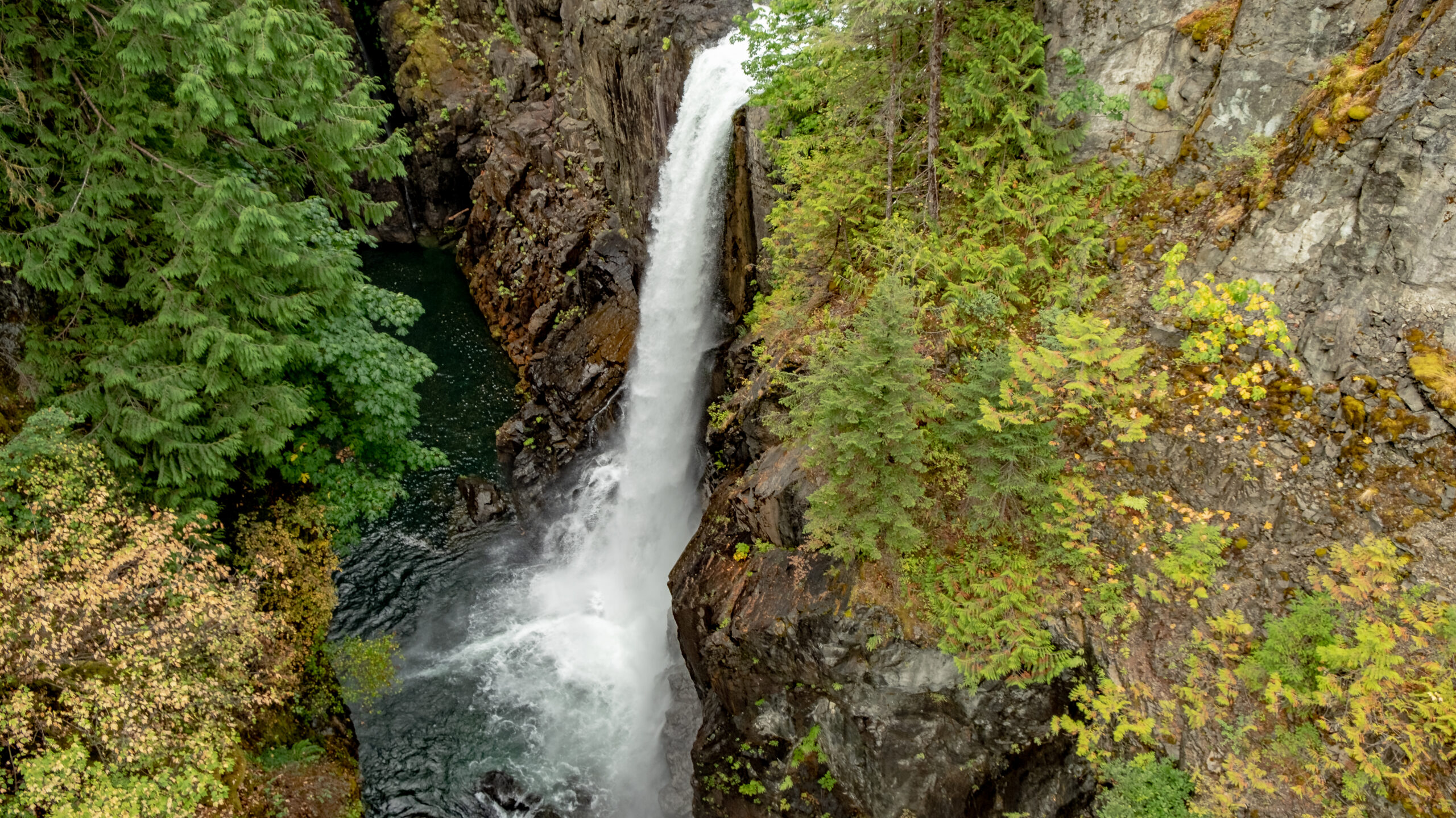
The next day, we continued our trip to Port Hardy. About 20 minutes out of Campbell River is a fantastic provincial park with a suspension bridge right beside the thundering 25 metre falls. I can be a little afraid of heights, but I made it across and back and across again halfway to take some more photos. The park has a number of walking trails through old-growth forest. It is beautiful and peaceful.
This is not the suspension bridge!Steps to the viewing platformCraig looking through the bridge floorFilming me on the return trip.Upper fallsJust hanging outFound his own way back to the top of the trail.
Proof that I crossed the bridge!
Coal Harbour
Craig’s grandparents lived in Port McNeill and he visited the area as a child. We went to Coal Harbour on our way to Port Hardy. Craig remembers visiting this area when there was still whaling happening in the harbour. Thankfully, that practice was discontinued in the 1960’s.
During WWII, the RCAF used this area as a base for seaplanes patrolling the Pacific. A big hangar remains and houses a museum that apparently features a 20 foot jawbone of a blue whale. Unfortuantely, we didn’t venture inside the hangar. These days, Coal Harbour is a mecca for sports fishing.
View of Coal Harbour from the pier
Old pontoons from Float Planes
Quatsino First Nations totem overlooking the docks
Port Hardy
We stayed two nights in Port Hardy to facilitate some further exploration, and also to be close to the BC Ferries for our trip to Prince Rupert. We walked along the waterfront, had fish and chips at a local food truck and met one of the hereditary chiefs of the Kwakiutl First Nations. He had just created music for his son to sing at an upcoming event. We also had great accommodation at the Kwa’lilas Hotel, a lovely First Nations destination hotel.
There is much more to explore in Port Hardy; however, we focused our attention on Telegraph Cove and Alert Bay on the full day that we were in the area.
Our final night, we had Sushi from Karai Sushi and Grill near the Port Hardy airport. It came highly recommended by a young man working at the Tourist Info office in Port MacNeil. It was very fresh and tasty! We understand that they will be opening another restaurant in downtown Port Hardy in the near future.
Sights along the shore in Port Hardy
Telegraph Cove
The focus of our full day in the area was on Alert Bay, but we made time to visit the picturesque Telegraph Cove in the morning. This community sprung from a one-room telegraph shack where fishermen, loggers and pioneers could keep in touch with the outside world. The community grew to include a fish saltery, sawmill, school and general store. Many of the buildings are built on stilts along the rocky shoreline. As we wandered through the colouful community, we read about the history of the various buildings many of which are cabins for rent. This is a centre for eco-tourism for Johnstone Strait and the Broughton Archipeligo. We didn’t have time for a tour, this time. Definitely on the list to come back to and stay for a few days.
We enjoyed an Americano at The Cove Coffee Company. The owner/barista made sure to understand how we liked our coffee. Craig had one of their famous cinnamon buns (with raisins) and I had a scone. All delicious and filled us up for our ferry ride to Alert Bay.
Alert Bay
We arrived in Port McNeill a little ahead of the 11:30am sailing so we had a peek in the Tourism Centre. Craig was hoping to see some old photos from the 1960’s as his grandparents lived here then. Unfortunately, the historian had retired and no photos were available to view.
Alert Bay is located on Cormorant Island and the ferry took about 45 minutes. The island is only 4 1/2 miles long and about 1 mile wide. Upon arrival we walked to the Tourist office to get directions to the Anglican cemetery where Craig thought his grandfather was buried. The woman there let us know that it was walkable, but there was a big hill to walk up. We walked along the main street boardwalk and had a look inside the Anglican Church. Then we found the path we needed to take. It was a hill…but only took about 10 minutes to get to the top.
The cemetery is quite overgrown, and had a majestic totem on the upper section ((Thunderbird, Killer Whale, Wolf). Craig and I searched the entire cemetery for a headstone of John Hunter Murchie, but with no success. Some plots appeared to have no headstone and others were so worn, it was impossible to see any lettering. Disappointing but not unexpected.
We had about an hour left before the ferry back to Port McNeill departed, so we walked down the hill through a residential area toward the U’mista Cultural Centre. We we were too late for the Kwok’Wala presentation explaining the history of outlawing ceremony potlaches in 1894 by the Government of Canada and the confiscation of ceremonial regalia and art work. U’mista’s purpose is to repatriate those artifacts.
Along the beach on our way to U’mista, we met Fred who was logging a driftwood cedar tree for shakes and for large pieces that he would have carved. Alert Bay is famous for indigenous carvers. We learned about his upbringing at Alert Bay, about the residential school that existed until the 1970’s, his moving away, and now returning to Alert Bay…or more specifically to ‘Namgis First Nation. He also told us who to reach out to for information on where Craig’s grandfathers grave is located.
The walk back to the ferry dock was pleasant. We spoke with many locals. Everyone was kind and welcoming. Next time, spending more time in the cultural centre and viewing more of the amazing totems on the island is in order.
Ferry from Port McNeillApproaching Alert BayAmazing artwork everywhereCraig searching for John Hunter Murchie’s gravestoneTotem at the Anglican CemeteryFred…a man with many storiesU’Mista Cultural CentreOne of many totems displayed at private residences
More of our travels to come…
Watch for the next installation of our travels – Port Hardy to Prince Rupert and beyond.